The authors discuss the sources of two major pollution spikes in the region - occurring between October and November, and again from March to April. They also explore the impacts of air pollution on the environment, socio-economic conditions, and public health, as well as some available solutions to address these sources at their origin
As the season of droughts and forest fires looms over Nepal, here’s a look at what could be done to avert the worst.
Droughts are a complex hazard due to their multifaceted causes, encompassing meteorological shifts, human activities, and socio-economic pressures.[1] This complexity is further amplified by the cascading hazards they trigger, most notably, in terms of the increased frequency and intensity of
forest fires.[1] The prolonged dry conditions of droughts desiccate vegetation, thereby providing ample fuel that render landscapes highly vulnerable to forest fires while also creating a setting for dangerous feedback loops.[2]
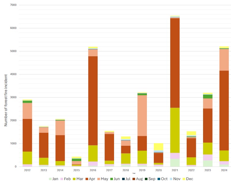
In Nepal, forest fires are getting more and more intense with each passing year. While the country saw a restoration of its forests due to national-level community forest management practices during the 1980 and ‘90s, the gains are now being challenged by the escalating impacts of climate change – reduced rainfall and drier winters (1, 2) These have led to forest fires becoming a recurring hazard. The figures speak for themselves – while in 2021, the country recorded over 6,000 forest fires, last year, 2024, saw more than 5,000 fires burn through the countryside.
Data from the Forest Fire Detection and Monitoring System (FFDMS) in Nepal (Graph 1) shows that the frequency of forest fires has more than doubled in the last decade, while 2025 is projected to be one of the worst years yet. Every two to three years, a high incidence of forest fire has been recorded. This increase is not just in terms of number, but also in terms of the scale and intensity of the fires.
An early and dire warning
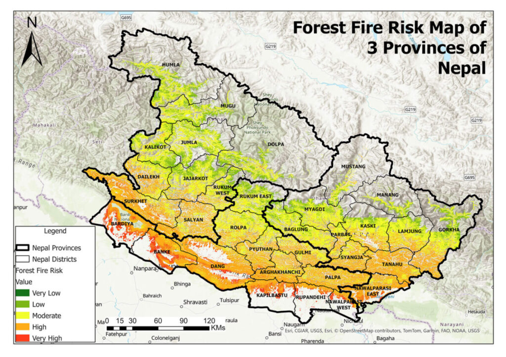
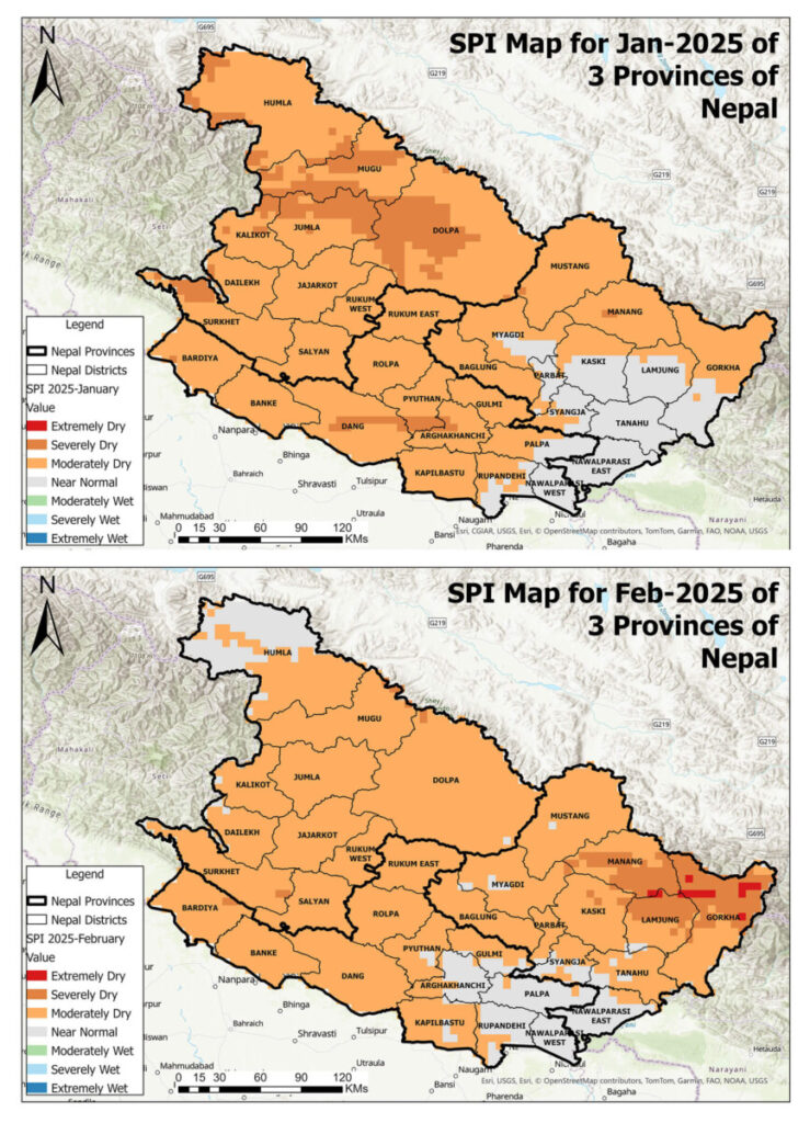
This year, the National Agricultural Drought Watch of Nepal has already issued an advanced warning of drought. The Standardized Precipitation Index (SPI) for the months of January and February (Map 2) showed that the majority of the districts were experiencing moderate to severe drought conditions. Almost every district in the western region of Nepal has been experiencing moderate to severe drought conditions. The forest fire risk map (below) also shows the districts that are vulnerable to forest fire. The map, which integrates climate, land-cover, and geophysical data, shows that some regions, particularly in the mid-hills and the Terai, are expected to face significantly higher risk of forest fires this year. Districts like Banke, Bardiya, Dang, Kailali, and Kanchanpur of Terai, and Surkhet, Salyan, Dadeldhura, Pyuthan, Doti, and Arghakhanchi of the hills have been identified as high-risk districts for forest fire. These areas have already been experiencing more frequent drought conditions and have become highly prone to higher temperatures and lower rainfall. The SPI has also shown moderate to severe drought conditions for these areas. The SPI map and the forest fire risk maps of Nepal reveal a strong correlation between drought severity and forest fire risk.
Drought acts as a silent yet potent trigger that causes devastating forest fires. It is not merely a prolonged dry spell but rather the build-up of a combination of several factors that lead to ideal conditions for the igniting and spreading of forest fires. The key factors include:
- Rising temperatures: Accelerated evapotranspiration leading to reduced soil and vegetation moisture.
- Prolonged dry conditions: Especially during winter, thereby exacerbating drought severity.
- Accumulation of dry biomass: Fallen leaves, twigs, and deadwood provide abundant fuel for forest fires, and enable flames to spread quickly across forested areas.
In the context of Nepal, these factors are particularly influenced by monsoonal pattern changes, deforestation, land-use changes, forest management activities (human and forest interactions manipulating forest fuel), and the effects of climate change.
As Graph 1 indicates so clearly and alarmingly, between the years 2012 and 2024, the frequency of forest fires escalated dramatically across Nepal, while more than 300 such incidents have already been recorded in the first two months of 2025, whereas the peak season for fires, which is usually the pre-monsoon months of March to May, is yet to come.
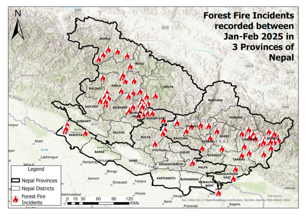
From 2012 to 2025, forest fires have consistently surged during the dry months, especially in the pre-monsoon season (March–May), which coincides with the peak of Nepal’s dry periods. The increased frequency of drought events, coupled with the severe drying of vegetation, creates a dangerous convergence of conditions conducive to fires. It is crucial to note that the districts that are the worst hit by forest fires are also the most affected by drought, which is an illustration of a vicious cycle that may only worsen with time.
Data from Graph 2 shows that districts like Banke, Bardiya, Chitwan, Dang, Surkhet, Kailali, and Kanchanpur experience higher incidents of forest fire (more than 1,500 forest fires from 2012 to 2024). These districts, located in the Terai, also suffer high temperatures and prolonged droughts, making them hotspots for forest fire outbreaks.
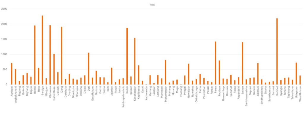
Meanwhile, hilly districts like Achham, Dadeldhura, Doti, Makwanpur, Pyuthan, Salyan, Sindhuli, and Udayapur, with their vast forested areas, also show a high frequency of forest fires, which further emphasises the link between drought severity and forest fire occurrence. The drought conditions in these areas increase the likelihood of fast-spreading fires that are difficult to control, and threaten both rural settlements and biodiversity. Each year, an average of 3,000 forest fire incidents were recorded in Nepal from 2012 to 2024, of which Banke, Bardiya, Surkhet, Chitwan, Dang, Kailali, Kanchanpur, Parsa, Salyan, Doti, and Dadeldhura recorded over 1,000 forest fire incidents each in 12 years.
The alarming future: Why action is urgent
As drought conditions intensify, Nepal is heading towards a future where forest fires could become a regular, uncontrollable phenomenon. This would contribute to climate change, worsen air quality, and displace local communities. Already this year, the air quality index (AQI) of Nepal’s major cities has touched the unhealthy mark, and the upcoming forest fire threat during the dry months is sure to further degrade the air we breathe.
In 2024, the major cities of Nepal breathed significantly poor air, with forest fires being a primary cause for the abysmal air quality. Similarly, in 2023, Nepal and its neighbouring countries saw air quality deteriorate due to forest fires and residential biomass burning. Analysis from ICIMOD’s air pollution dashboard showed elevated levels of carbon monoxide, which, when inhaled, can lead to changes in lung function and make breathing difficult.
Furthermore, forest fires are a precursor to other hazards. They can cause soil erosion and landslides, particularly in mountainous terrains. During such fires, all the vegetation, including the root structure which stabilises the soil, burns out, leading to increased surface run-off and weakened slopes. So, in fire-affected slopes, even moderate rainfall can trigger a landslide and also move debris and sediments into rivers and block waterways, thereby threatening life downstream.
Forest fire monitoring in Nepal
It was based on the pressing need for a scientific forest fire detection and monitoring mechanism that ICIMOD and Nepal government’s Department of Forests and Soil Conservation (DoFSC) jointly developed the web-based FFDMS. This tool serves as a key resource for forest fire risk assessment, monitoring, and management, thereby enabling decision-makers to enhance preparedness and responses during forest fires. In addition, it not only provides real-time information on the occurrence of forest fires but also sends SMSs and email alerts to officials of all forest divisions, subdivisions, and to the members of community forest user’s groups nationwide.
Badri Raj Dhungana, Director General of DoFSC,emphasised the significance of this system in enhancing Nepal’s fire-response capabilities, stating, “Such technological innovations can serve as a critical tool in enabling the authorities to act swiftly, thereby minimising damage and improving disaster preparedness.” He also stressed on the importance of fire prevention regulations, saying, “Strict fire prevention regulations must be implemented and those individuals responsible for starting fires should be penalised. There should also be incentive mechanisms to encourage the reporting of fire incidents by local authorities.”
What next?
As the months of forest fire incidents are approaching, it is time for immediate action. In addition to this warning and monitoring system, the government, local authorities, and communities must work together to strengthen the firefighting capacity, implement strict forest fire prevention measures, and invest in reforestation and fire-resistant vegetation. Constructing firebreaks in high-risk areas and implementing sustainable forest management practices can help contain fire spread. Public awareness campaigns are also critical to educate citizens about the dangers of forest fire and the role drought plays in exacerbating forest fire risks. A community-based fire management (CBFiM) approach can empower local residents to take an active role in early fire detection, prevention, and suppression efforts. Furthermore, integrating fire risk assessments into national disaster preparedness strategies will enable policymakers to proactively address fire-prone zones and implement preventive measures before peak dry seasons.
Additionally, strengthening Nepal’s firefighting capacity through the provision of modern equipment, advanced training, and remote sensing technologies is essential to combat forest fire effectively. The combination of earth observation systems, early drought monitoring, and robust forest fire management plans in land use planning can help mitigate this growing threat and create long-term resilience.


